|


| |
-
Brazil - Sao Paulo State (Chapter)
SÃO PAULO
-
|
São Paulo
São
Paulo occupies na área of 248,808.8 sq. kms. and contains one of
the most heavily populated conurbations in the world. Its
capital is the city of São Paulo, with more than 10 million
inhabitants. The metropolitan region around the city of São
Paulo has over 16 million inhabitants. São Paulo is the most
developed state in the country, with an economy based on
agriculture, ranching, commerce, services, and industry. The
state includes the ABC region, where the country’s largest
industries are located. The cities of Santo André, São Bernardo
do Campo, São Caetano, and Diadema comprise the region known as
the ABCD.
History
Colonization of the area began in 1532, when Martim Afonso de
Sousa founded the Village (“Vila”) of São Vicente. In 1554 the
Jesuits organized a nucleus around which the city began to take
shape. In the 17th century inhabitants of São Paulo formed bands
of adventurers (“bandeiras”) who penetrated the interior in
search of mineral wealth and native labor. The expansion of
coffee cultivation in the 19th century contributed to region’s
economic development. The resultant accumulation of capital and
the arrival of qualified European immigrants made
industrialization possible. At the same time the socioeconomic
profile of the province was changing, the phenomenon of
urbanization attracted Brazilians looking for work from other
regions.
With its neighbor, Minas Gerais, São Paulo dominated the
Brazilian political scene at the beginning of the 20th century
through a strategy that came to be known as “coffee with milk”:
São Paulo, which produced coffee, took turns heading the federal
government with Minas Gerais, which produced milk. In 1932
residents of São Paulo organized the Constitutionalist
Revolution, calling for the redemocratization of the country –
but they were defeated by the federal government, which went so
far as to shell the capital. Nowadays, São Paulo’s industrial
park presents an advanced stage of evolution and diversification
and has been expanding to other regions of Brazil.
|
Location: |
Southeastern Region
|
|
Capital: |
São Paulo
|
|
Population: |
37,035,456 (IBGE, 2000 Population Census)
|
|
GDP 2001: |
US$ 126.7 billion (R$ 400 billion)
|
|
Per capita GDP: |
US$ 3,373.05 (R$ 10,642.00)
|
|
Number of municipalities: |
645
|
|
Representation in the National Legislature: |
three senators and 46 federal deputies
|
|
Illiteracy rate: |
6.2% (2000 Census)
|
|
Unemployment rate: |
11.5% (IBGE 2002)
|
|
Largest cities: |
São Paulo (10,434,252), Guarulhos (1,072,717), Campinas
(969,396), São Bernardo do Campo (703,177), Osasco
(652,593)
|
|
Vegetation: |
Mangrove swamps along the coast, Atlantic Rain Forest and
tropical forest in the rest of the territory
|
|
Climate: |
Tropical
|
|
Average annual temperature: |
20°C
|
|
|
|
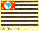
The flag of the São Paulo State is the representative flag used by the people during
the Constitutional Revolution in 1932. On 16th July, 1888, the newspaper "O
Rebate", which was founded by the writer Julio Ribeiro and used as a vehicle of
republican ideas presented a flag formed by fifteen alternating stripes (8 black stripes
and 7 white stripes) having on its superior corner a red rectangle. According to Júlio
Ribeiro, the "paulista" flag symbolizes the three Brazilian races (the white,
the black and the red race), having heraldic legitimization and colors harmonically
distributed, recognized by the possessors of coat of arms of all countries.
Nowadays, the flag is formed by thirteen horizontal stripes (7 of them black
and 6 white) and a red rectangle on its superior left corner. inside of it there is a
silver circle with the geographic outline of the Brazilian Territory in blue and four
golden stars on its angles.
São Paulo is the largest city of both South America and Brazil as well as the
capital of Brazil's richest state, São Paulo. Located in the southeastern part of the
country on the Tiete River, about 55 km (35 mi) inland from SANTOS, Brazil's principal
port, São Paulo is the country's leading manufacturing and financial center.
Founded by Jesuits in 1554, São Paulo served during the 17th and 18th
centuries as a base for Portuguese settlement of the interior. In 1822 it was the city in
which Emperor Pedro I proclaimed Brazil's independence from Portugal. In the 1880s, São
Paulo state became a major coffee-growing region
Many
Pictures
of São Paulo and its cities...
Pictures of just São Paulo...
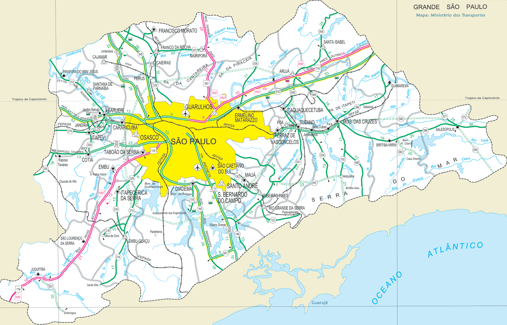
 Map of Sao Paulo
- Links to São Paulo and its cities...
Interior
São Paulo
|